
Iowa Crop Progress and Condition Report
July 3-9, 2023
DES MOINES, Iowa (July 10, 2023) – Iowa Secretary of Agriculture Mike Naig commented today on the Iowa Crop Progress and Condition Report released by the USDA National Agricultural Statistics Service. The report is released weekly April through November. Additionally, the Iowa Department of Agriculture and Land Stewardship provides a weather summary each week during this time.
“Widespread showers and thunderstorms, along with unseasonably cool temperatures, brought relief to farmers and moisture stressed crops across Iowa last week,” said Secretary Naig. “As corn tassels continue to emerge, thunderstorms remain in the forecast over the next several days along with near-seasonal temperatures.”
The weekly report is also available on the USDA’s website at nass.usda.gov.
Crop Report
Western Iowa was the recipient of some much-needed precipitation this week and farmers, statewide, had 5.3 days suitable for fieldwork during the week ending July 9, 2023, according to the USDA, National Agricultural Statistics Service. Field activities included cutting hay and spraying crops. Some reports were received of farmers beginning to harvest oats for grain.
Topsoil moisture condition rated 15 percent very short, 42 percent short, 42 percent adequate and 1 percent surplus. Subsoil moisture condition rated 19 percent very short, 45 percent short, 35 percent adequate and 1 percent surplus.
Corn silking hit 22 percent this week, 6 days ahead of last year and 2 days ahead of the 5-year average. Some reports were received of corn starting to dough. Corn condition remained steady at 61 percent good to excellent. Forty-six percent of soybeans were blooming, 5 days ahead of last year and 3 days ahead of the average. Soybeans setting pods reached 7 percent, 4 days ahead of last year and 1 day ahead of normal. Soybean condition rated 52 percent good to excellent. Sixty-seven percent of oats were turning color, 8 days ahead of last year and 5 days ahead of normal. Oat condition improved slightly with 52 percent good to excellent.
The State’s second cutting of alfalfa hay reached 58 percent complete, 9 days ahead of last year and 1 week ahead of the average. Hay condition improved slightly to 35 percent good to excellent. Pasture condition rated 24 percent good to excellent. Livestock producers continued to supplement with hay as pasture conditions remained below average.
Weather Summary
Provided by Justin Glisan, Ph.D., State Climatologist, Iowa Department of Agriculture and Land Stewardship
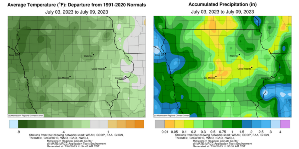
Showers and thunderstorms produced widespread rainfall through the reporting period with pockets of near-normal to above-average totals in western, northeast and southeast Iowa; some stations measured one to three inches of above-normal amounts. The rest of the state had rainfall deficits in the 0.50-1.00-inch range. Temperatures were also unseasonably cool with negative departures of up to seven degrees northwest; the statewide average temperature was 68.8 degrees, 5.5 degrees below normal.
Showers cleared eastern Iowa through Sunday (2nd) afternoon as mostly clear conditions and highs in the low to mid-80s were reported across much of the state. Calm to light, variable winds continued overnight into Monday (3rd) with morning lows in the low to mid-60s and reports of patchy fog southwest and southeast. Southwesterly winds increased through the day with daytime temperatures rising into the upper 80s and low 90s under sunny skies. Spotty thunderstorms, some severe-warned, fired in northwestern Iowa later in the afternoon before dissipating after sunset. Another round formed after midnight in northeastern Iowa. Rain totals at 7:00 am on Tuesday (4th) were above 0.50 inch at 10 stations with Oelwein (Fayette County) observing 1.15 inches while Strawberry Point (Clayton County) measured 1.29 inches. Showers associated with an approaching low-pressure system pushed into the northwest corner just before noon where daytime highs held in the 70s, while upper 80s and low 90s were observed farther east. As the low’s attendant cold front moved over the Nebraska border, severe thunderstorms formed but lost strength over the next few hours as fireworks streaked across the sky. Widespread rain totals above 0.25 inch were reported in western Iowa with higher amounts ranging from 0.73 inch at Rock Rapids (Lyon County) to 2.26 inches in Mapleton (Monona County). Thunderstorms dissipated as the front moved through central Iowa into Wednesday (5th) morning but refired stronger storms along the Iowa-Illinois border in the early afternoon; Burlington (Des Moines County) registered 0.79 inch while Salem (Henry County) collected 1.11 inches. Northerly winds built in behind the front along with cooler high temperatures in the 70s.
Thursday (6th) started with morning lows in the mid-50s northwest to mid-60s southeast under clear skies with a light, northerly wind. Partly cloudy skies developed into the afternoon hours with pleasant highs in the 70s. Clouds increased over western Iowa close to sunrise on Friday (7th) as another low-pressure center approached from Nebraska. A broad area of showers and thunderstorms developed and pushed across Iowa for the remainder of the day. Temperatures were unseasonably cool statewide with upper 50s to mid-60s west to east. Most of Iowa’s stations reported measurable rainfall with widespread amounts in the 0.25-0.75-inch range in western and southern Iowa; peripheral stations measured a tenth or two with a statewide average of 0.23 inch. Burlington and Salem again received totals over an inch, registering 1.65 inches and 1.97 inches, respectively. Fog formed overnight into Saturday (8th) as winds shifted to the northwest with daytime conditions reaching into the mid to upper 70s under mostly sunny skies. Winds died down and became variable after sunset with isolated clouds moving across southern Iowa. Sunday (9th) morning saw a wide range of temperatures from spotty upper 40s in northwest Iowa to low 60s in eastern Iowa.
Weekly rain totals ranged from no accumulation at several north-central stations to 3.11 inches in Salem. The statewide weekly average precipitation was 0.64 inch, while the normal is 1.07 inches. Sioux City Airport (Woodbury County) reported the week’s high temperature of 96 degrees on the 3rd, 11 degrees above normal. Vinton (Benton County) reported the week’s low temperature of 42 degrees on the 7th, 18 degrees below normal.
###
About the Iowa Department of Agriculture and Land Stewardship
Led by Secretary Mike Naig, the Department of Agriculture and Land Stewardship serves the rural and urban residents that call Iowa home. Through its 14 diverse bureaus, the Department ensures animal health, food safety and consumer protection. It also promotes conservation efforts to preserve our land and enhance water quality for the next generation. Learn more at iowaagriculture.gov.
美国谷物与生物产品协会简介
美国谷物与生物产品协会成立于1960年,是一家私立的非营利性机构。协会致力于拓展美国谷物市场,与美国种植者、农业企业及公共部门一道,为全球客户提供国际市场服务。美国谷物与生物产品协会会员包括各州谷物种植者、乙醇加工厂、行业组织、贸易公司及农业企业。协会总部位于华盛顿特区,在全球设有9个国际办事处,业务覆盖30个国家,并在全球70多个国家开展项目。自1982年起,美国谷物与生物产品协会设立了北京办事处,在华开展饲料谷物相关项目,参与并推动了中国的饲料和养殖行业、玉米深加工及燃料乙醇等领域的发展。美国谷物与生物产品协会提供的服务还包括:贸易服务、谷物市场信息、生产养殖技术及管理等相关培训。美国谷物与生物产品协会愿持续努力,继续加强中美两国的行业交流,加深相互了解,建立长久的互惠互利的伙伴关系。