
Iowa Crop Progress and Condition Report
April 18 – 24, 2022
DES MOINES, Iowa (April 25, 2022) – Iowa Secretary of Agriculture Mike Naig commented today on the Iowa Crop Progress and Condition Report released by the USDA National Agricultural Statistics Service. The report is released weekly April through November.
“It was another active weather week with additional periods of severe thunderstorms and locally heavy rainfall,” said Secretary Naig. “Cooler temperatures and windy conditions also persisted, though soil temperatures are slowly rising. Soil temperatures are at or above 50 degrees for much of the southern two-thirds of Iowa.”
The weekly report is also available on the USDA’s website at nass.usda.gov.
Crop Report
Rain, high winds, and cold conditions continued to stall spring planting, limiting Iowa farmers to 2.3 days suitable for fieldwork during the week ending April 24, 2022, according to the USDA, National Agricultural Statistics Service. Fieldwork activities were primarily applying anhydrous and fertilizer. Reports were received of limited corn and soybean planting as well as planting oats. In addition to periodic precipitation, cool soil temperatures have some farmers waiting to plant row crops.
Topsoil moisture condition rated 4 percent very short, 18 percent short, 67 percent adequate and 11 percent surplus. Subsoil moisture condition rated 9 percent very short, 29 percent short, 58 percent adequate and 4 percent surplus.
Forty-seven percent of the expected oat crop has been planted, 10 days behind last year and 5 days behind the 5-year average.
Pastures were slowly turning green. Hay supplies were dwindling in some areas. Livestock conditions were generally good, with calving in full swing.
Weather Summary
Provided by Justin Glisan, Ph.D., State Climatologist, Iowa Department of Agriculture and Land Stewardship
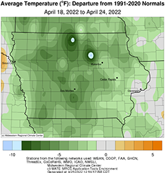
Several rounds of showers and thunderstorms brought moderate to heavy rain across central and eastern Iowa through the reporting period; some stations measured over two inches of above average rainfall. The active storm track produced multiple occurrences of severe straight-line winds, large hail and an isolated tornado. Unseasonably cool temperatures also persisted with departures of up to nine degrees below normal; the statewide average temperature was 48.4 degrees, 4.3 degrees below normal.
Light rain and snow showers continued Easter Sunday (17th) afternoon with a band of 1.5 – 3.0 inch snow totals measured from south-central into northwestern Iowa; a station near Indianola (Warren County) reported 4.0 inches. Afternoon highs ranged from the low 30s northwest to low 40s southeast. Most of Iowa’s stations observed measurable precipitation totals at 7:00 am on Monday (18th) in the range of 0.20 to 0.40 inch. A dome of high pressure took control of the weather pattern as winds shifted to the northwest with clearing skies in western Iowa. Under sunny skies, daytime temperatures pushed into the upper 40s and low 50s, while upper 30s and low 40s blanketed eastern Iowa where clouds persisted. Starry skies and variable winds were reported into Tuesday (19th) morning with lows in the 20s. Cloud cover gradually increased from west to east through the afternoon and evening hours as southwesterly winds became gusty. A warm front and return flow continued to warm temperatures across southern Iowa overnight and hold them in the upper 40s and low 50s by sunrise on Wednesday (20th). A fast moving disturbance produced scattered showers throughout the day with most of Iowa reporting measurable totals. Much of Iowa’s eastern two-thirds measured at least 0.25 inch with totals over 0.75 inch in the southeast corner; Donnellson (Lee County) observed 1.25 inches. Under clear skies, windless conditions and ample low-level moisture, very dense fog formed overnight and persisted through the late morning on Thursday (21st) until increasing winds and solar heating mixed out the lower atmosphere. Afternoon highs, in the upper 50s to mid 60s, were pleasant under mostly sunny skies.
A line of showers formed in the late evening over southern Iowa and pushed north along an atmospheric boundary. The area of rain expanded across central and northern Iowa as severe storms pushed into western Iowa prior to sunrise on Friday (22nd). Pockets of heavier rainfall associated with slow-moving thunderstorms produced flash flooding across several central Iowa counties with rain rates approaching three inches per hour. The disturbance exited eastern Iowa in the early afternoon as gusty southerly winds built in. A strong warm front lifted north over Iowa, pushing daytime temperatures into the upper 70s and low 80s in southern and western Iowa; temperatures remained in the low 60s northeast; the statewide average high was 73 degrees, 10 degrees above normal. Overnight temperatures remained unseasonably warm, holding in the upper 60s and low 70s in southwestern Iowa. A line of strong thunderstorms rapidly formed ahead of a strong low pressure disturbance and moved across western Iowa after sunrise on Saturday (23rd). Some storms turned severe as the line raced into central Iowa before dissipating northeast. A second, stronger squall line formed along the low’s attendant cold front during the late afternoon hours as temperatures hovered in the mid to upper 70s with ample instability. Several storms turned severe through the evening hours with multiple reports of 60 – 70 mph winds and quarter-sized hail; a weak tornado was also spotted near Sheldahl (Boone County). Pockets of heavier rain totals were found in south-central Iowa with general storm amount between a tenth and half of an inch. A gauge in Des Moines (Polk County) measured 1.06 inches with a statewide average at 0.20 inch reported at 7:00 am Sunday (24th).
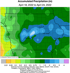
Weekly precipitation totals ranged from 0.08 inch at Randolph (Fremont County) to 4.80 inches in Maxwell (Story County). The statewide weekly average precipitation was 1.35 inches while the normal is 0.90 inch. Sioux City Airport (Woodbury County) reported the week’s high temperature of 86 degrees on the 22nd, 23 degrees above average. Atlantic (Cass County) and Audubon (Audubon County) reported the week’s low temperature of 16 degrees on the 19th, on average 21 degrees below normal. Four-inch soil temperatures were in the upper 40s northwest to upper 50s southeast as of Sunday.
About the Iowa Department of Agriculture and Land Stewardship
Led by Secretary Mike Naig, the Department of Agriculture and Land Stewardship serves the rural and urban residents that call Iowa home. Through its 14 diverse bureaus, the Department ensures animal health, food safety and consumer protection. It also promotes conservation efforts to preserve our land and enhance water quality for the next generation. Learn more at iowaagriculture.gov.
美国谷物与生物产品协会简介
美国谷物与生物产品协会成立于1960年,是一家私立的非营利性机构。协会致力于拓展美国谷物市场,与美国种植者、农业企业及公共部门一道,为全球客户提供国际市场服务。美国谷物与生物产品协会会员包括各州谷物种植者、乙醇加工厂、行业组织、贸易公司及农业企业。协会总部位于华盛顿特区,在全球设有9个国际办事处,业务覆盖30个国家,并在全球70多个国家开展项目。自1982年起,美国谷物与生物产品协会设立了北京办事处,在华开展饲料谷物相关项目,参与并推动了中国的饲料和养殖行业、玉米深加工及燃料乙醇等领域的发展。美国谷物与生物产品协会提供的服务还包括:贸易服务、谷物市场信息、生产养殖技术及管理等相关培训。美国谷物与生物产品协会愿持续努力,继续加强中美两国的行业交流,加深相互了解,建立长久的互惠互利的伙伴关系。