
Iowa Crop Progress and Condition Report
October 31 – November 1, 2022
DES MOINES, Iowa (November 7, 2022) — Iowa Secretary of Agriculture Mike Naig commented today on the Iowa Crop Progress and Condition Report released by the USDA National Agricultural Statistics Service. The report is released weekly April through November.
“Soybean harvest is nearing completion with corn close behind and farmers are also busy with other fall field work as conditions allow,” said Secretary Naig. “Portions of the state received nearly a month’s worth of badly needed moisture last week. Looking ahead, we will see a few more days of warm and dry conditions before a weather pattern change ushers in colder air.”
The weekly report is also available on the USDA’s website at nass.usda.gov.
Crop Report
Warm and dry conditions early in the week helped accelerate row crop harvest, which remained ahead of average with 5.3 days suitable for fieldwork during the week ending November 6, 2022, according to the USDA, National Agricultural Statistics Service. Fieldwork included harvesting row crops, completing fall tillage, anhydrous application, baling stalks, seeding cover crops, and applying manure.
Topsoil moisture condition rated 17 percent very short, 37 percent short, 44 percent adequate and 2 percent surplus. Subsoil moisture condition rated 25 percent very short, 39 percent short, 36 percent adequate and 0 percent surplus.
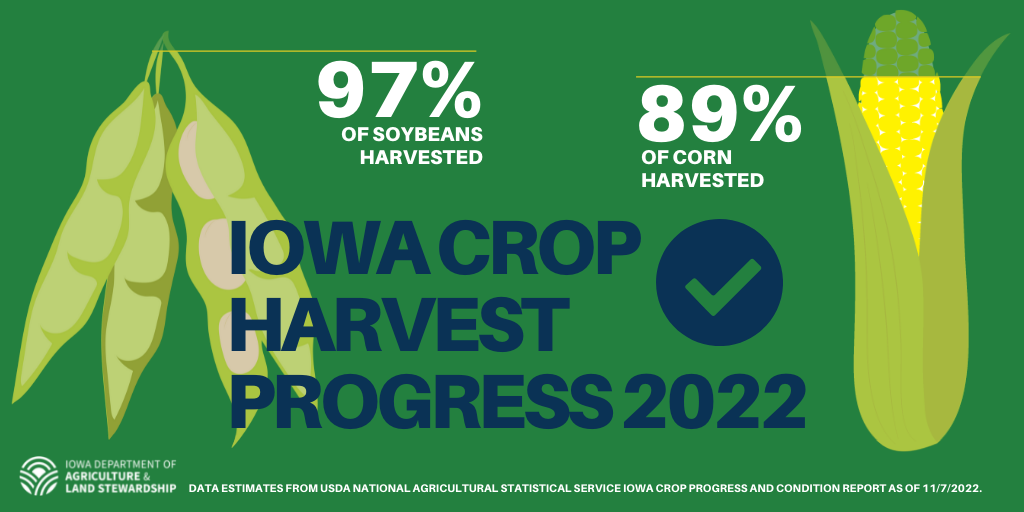
Harvest of the corn for grain crop reached 89 percent complete, 6 days ahead of last year and 11 days ahead of the average. Moisture content of field corn being harvested for grain remained 17 percent.
Soybean harvest was virtually complete at 97 percent, 8 days ahead of last year and 9 days ahead of the average.
Livestock were mostly doing well, with some reports of calves being treated for pneumonia.
Weather Summary
Provided by Justin Glisan, Ph.D., State Climatologist, Iowa Department of Agriculture and Land Stewardship
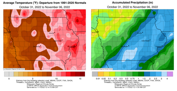
Much-needed and above-average rainfall was observed across the southeastern half of Iowa through the first week of November. Positive departures between two to three inches were common at several south-central and eastern stations. Unseasonably warm temperatures also blanketed the state with a statewide average temperature of 51.0 degrees, 8.3 degrees above normal.
Showers spun into Iowa’s southeastern corner through early Sunday (30th) afternoon as generally clear, warm conditions were reported across the rest of the state. Several stations reported a few tenths of an inch with a gauge in New London (Henry County) measuring 0.34 inch. Daytime temperatures reached into the mid 60s in western and southern Iowa with upper 50s in the northeast. A wide range of overnight lows spanned the state with mid 20s in the northwest to low 50s southeast reported at 7:00 am on Monday (31st). Winds out of the west and sunny skies held afternoon temperatures in the mid to upper 60s as high pressure dominated the Midwest. Winds shifted to a southerly direction into Tuesday (1st) with unseasonably warm temperatures in the mid to upper 70s statewide under clear skies. Overnight conditions were cloudless as temperatures held in the upper 40s and low 50s with southerly winds becoming blustery on Wednesday (2nd). Daytime highs pushed into the 70s for a second day as sustained winds held in the 20 to 30-mph range in northwestern Iowa; the statewide average high was 74 degrees, 21 degrees above normal.
Cloud cover increased west to east into Thursday (3rd) morning as a low pressure system approached Iowa from the west. Gusty southerly winds continued, pumping moisture into the Midwest as highs ranged from the upper 60s north to mid 70s south. Showers began forming in western Iowa after sunset as the low pressure center pushed across Iowa. Widespread showers and some thunderstorms continued overnight and through Friday (4th) leaving behind beneficial totals over much of Iowa. Dreary conditions were observed throughout the day as rain continued and highs hovered in the upper 30s and low 40s. The system held on in eastern Iowa through Saturday (5th) afternoon as sunshine broke out in western Iowa. Most Iowa stations reported measurable totals from the event with nearly 100 stations measuring at least an inch. More than 50 stations observed two or more inches with stations in south-central Iowa reporting the highest totals; Lamoni (Decatur County) dumped out 3.51 inches while Osceola (Clarke County) reported 4.18 inches. As clouds dissipated, temperatures rebounded into the 50s west while mid 40s were present in eastern Iowa. Winds shifted to a southerly direction late in the night before swinging back around the west by sunrise on Sunday (6th). Morning lows were warmer than average with mid to upper 40s over northern Iowa with warmer conditions farther south.
Weekly rain totals ranged from 0.01 inch at Estherville Municipal Airport (Emmet County) to 4.30 inches in Osceola. The statewide weekly average rainfall was 1.47 inches; the normal is 0.54 inch. Lamoni (Decatur County) and Little Sioux (Harrison County) reported the week’s high temperature of 80 degrees on the 2nd, on average 24 degrees above normal. Sibley (Osceola County) and Sioux City Airport (Woodbury County) reported the week’s low temperature of 23 degrees on the 5th, on average five degrees below normal. Four-inch soil temperatures were in the mid 40s north to low 50s south as of Sunday.
###
About the Iowa Department of Agriculture and Land Stewardship
Led by Secretary Mike Naig, the Department of Agriculture and Land Stewardship serves the rural and urban residents that call Iowa home. Through its 14 diverse bureaus, the Department ensures animal health, food safety and consumer protection. It also promotes conservation efforts to preserve our land and enhance water quality for the next generation. Learn more at iowaagriculture.gov.
美国谷物与生物产品协会简介
美国谷物与生物产品协会成立于1960年,是一家私立的非营利性机构。协会致力于拓展美国谷物市场,与美国种植者、农业企业及公共部门一道,为全球客户提供国际市场服务。美国谷物与生物产品协会会员包括各州谷物种植者、乙醇加工厂、行业组织、贸易公司及农业企业。协会总部位于华盛顿特区,在全球设有9个国际办事处,业务覆盖30个国家,并在全球70多个国家开展项目。自1982年起,美国谷物与生物产品协会设立了北京办事处,在华开展饲料谷物相关项目,参与并推动了中国的饲料和养殖行业、玉米深加工及燃料乙醇等领域的发展。美国谷物与生物产品协会提供的服务还包括:贸易服务、谷物市场信息、生产养殖技术及管理等相关培训。美国谷物与生物产品协会愿持续努力,继续加强中美两国的行业交流,加深相互了解,建立长久的互惠互利的伙伴关系。