
Iowa Crop Progress and Condition Report
August 29 – September 4, 2022
DES MOINES, Iowa (Sept. 6, 2022) — Iowa Secretary of Agriculture Mike Naig commented today on the Iowa Crop Progress and Condition Report released by the USDA National Agricultural Statistics Service. The report is released weekly April through November.
“The weather could not have been better for Farm Progress Show attendees last week as exhibitors highlighted and demonstrated the latest innovations across the ag sector,” said Iowa Secretary of Agriculture Mike Naig. “Now that we are past the Labor Day holiday and the days of summer dwindle, farmers are keeping a close eye on outlooks in preparation for harvest. With the potential for warm and dry conditions through fall, we need to remain vigilant for potential fire hazards as combines start to roll.”
The weekly report is also available on the USDA’s website at nass.usda.gov.
Crop Report
Continuing mostly dry conditions across most of the State resulted in 6.1 days suitable for fieldwork during the week ending September 4, 2022, according to the USDA, National Agricultural Statistics Service. Fieldwork included harvesting corn for silage, cutting hay, seeding cover crops, and preparing equipment for harvest.
Topsoil moisture condition rated 16 percent very short, 30 percent short, 53 percent adequate and 1 percent surplus. Subsoil moisture condition rated 19 percent very short, 31 percent short, 49 percent adequate and 1 percent surplus. Moisture levels in the Northwest, West Central, Southwest, South Central and Southeast Districts of Iowa continued to be a concern with over 50 percent of both topsoil and subsoil considered short to very short.
Corn in or beyond dough stage was 96 percent. Seventy-one percent of Iowa’s corn crop reached the dent stage or beyond, 3 days behind last year but 1 day ahead of average. Ten percent of the State’s corn crop was mature, 2 days behind both last year and the 5-year average. Corn condition remained 66 percent good to excellent. Ninety-seven percent of soybeans were setting pods. Soybeans coloring or beyond reached 20 percent, 5 days behind last year and 4 days behind the 5-year average. Soybeans began dropping leaves at 2 percent, 1 week behind last year and almost a week behind the average. Soybean condition rated 66 percent good to excellent. Oats harvested for grain neared completion at 96 percent.
Seventy-six percent of the State’s third cutting of alfalfa hay was complete, 5 days behind average. Pasture condition rated 32 percent good to excellent. Producers were supplementing short pastures with hay and grain.
Weather Summary
Provided by Justin Glisan, Ph.D., State Climatologist, Iowa Department of Agriculture and Land Stewardship
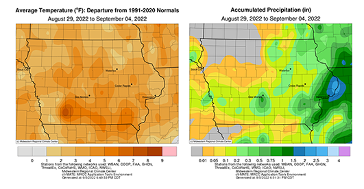
The day count for meteorological summer ran out over the reporting period as cooler temperatures filtered into the state towards the weekend. Weekly temperatures were still unseasonably warm with positive departures of up to four degrees; the statewide average temperature was 71.4 degrees, 1.4 degrees above normal. Rainfall was also below average statewide with departures approaching 0.80 inch. Only a handful of stations in eastern Iowa measured above-average totals.
Showers and thunderstorms continued to push out of eastern Iowa through Sunday (28th) afternoon as clouds cleared across western Iowa. Lower 80s were reported in eastern Iowa, where the sun was shielded behind cumulus clouds, while upper 80s were found farther west. A secondary cold front moved through Iowa overnight, producing spotty thunderstorms in western and central Iowa just before sunrise. Rain totals reported at 7:00 am on Monday (29th) were highest in northeastern and east-central Iowa, with more and 0.50 inch measured at 20 stations; Calamus (Clinton County) reported 1.13 inches while Cresco (Winneshiek County) observed 1.40 inch. A narrow line of severe-warned thunderstorms continued through central and southern Iowa through the late morning hours before crossing the Iowa-Illinois border before noon. Accumulating rains were isolated to Iowa’s southeastern one-quarter with Chariton (Lucas County) picking up 0.22 inch and a 0.64 inch-total found in Muscatine (Muscatine County). Winds shifted to the northwest behind the front with seasonal high temperatures in the low 80s under clear skies. Starry skies persisted into Tuesday (30th) morning as calm conditions allowed temperatures to drop in the upper 40s and low 50s in western Iowa; upper 50s and low 60s blanketed eastern Iowa as the sun rose. Daytime highs were very pleasant, reaching into the mid 70s east to low 80s west under a nice northerly breeze and cloudless skies. Winds shifted to an easterly direction as darkness overtook Iowa into Wednesday (31st) with morning lows in the 50s statewide. Afternoon temperatures were warmer than the previous days as southerly winds helped boost readings into the upper 80s and low 90s south and west with mid to upper 80s northeast. A few spotty thundershowers held together over the South Dakota border into the evening hours before dissipating.
Partly cloudy skies developed into early Thursday (1st) as a disturbance approached western Iowa. Afternoon conditions varied from upper 80s and low 90s northwest to upper 70s to mid 80s south, where clouds tamped down on daytime heating as showers developed. This cluster of rainfall expanded into central Iowa through the evening hours as a few thundershowers also fired. Rainfall dissipated in northeast Iowa through the later morning hours on Friday (2nd) as clearing skies greeted most of Iowa’s reporting stations. Morning lows remained in 60s with generally light rainfall totals observed along a narrow swath; a handful of stations reported over 0.30 inch with Garwin (Tama County) registering 0.33 inch and Norwalk (Warren County) dumping out 1.02 inches. Southerly winds built back in through the day as a cold front dropped southeast, pushing temperatures in the low 90s over much of Iowa. Temperatures behind the front remained in the lower 80s. A few isolated, near-stationary thunderstorms popped in southern Iowa through the evening hours along with more scattered cells along the frontal boundary into nighttime. Cooler air flowed in behind the cold front as winds shifted to the north; 50s were observed in western Iowa with mid 60s still hanging on in the east. Saturday (3rd) was a seasonal day in Iowa with daytime temperatures in the upper 70s and low 80s under brilliant sunshine. Chilly overnight lows greeted sunrise on Sunday (4th) with upper 40s and low 50s statewide.
Weekly precipitation totals ranged from no accumulation at several northwestern Iowa stations to 1.80 inches at the National Weather Service office in Davenport (Scott County). The statewide weekly average precipitation was 0.25 inch while the normal is 0.90 inch. Donnellson (Lee County) and Osceola (Clarke County) reported the week’s high temperature of 95 degrees on the 29th and 2nd, respectively, on average 12 degrees above normal. Airports in Spencer (Clay County) and Sioux City (Woodbury County) reported the week’s low temperature of 47 degrees on the 4th, on average eight degrees below normal.
###
About the Iowa Department of Agriculture and Land Stewardship
Led by Secretary Mike Naig, the Department of Agriculture and Land Stewardship serves the rural and urban residents that call Iowa home. Through its 14 diverse bureaus, the Department ensures animal health, food safety and consumer protection. It also promotes conservation efforts to preserve our land and enhance water quality for the next generation. Learn more at iowaagriculture.gov.
美国谷物协会简介
美国谷物协会成立于1960年,是一家私立的非营利性机构。协会致力于拓展美国谷物市场,与美国种植者、农业企业及公共部门一道,为全球客户提供国际市场服务。美国谷物协会会员包括各州谷物种植者、乙醇加工厂、行业组织、贸易公司及农业企业。协会总部位于华盛顿特区,在10个国家和地区设有办公室,所开展的业务覆盖全球50多个国家。自1982年起,美国谷物协会设立了北京办事处,在华开展饲料谷物相关项目,参与并推动了中国的饲料和养殖行业、玉米深加工及燃料乙醇等领域的发展。美国谷物协会提供的服务还包括:贸易服务、谷物市场信息、生产养殖技术及管理等相关培训。美国谷物协会愿持续努力,继续加强中美两国的行业交流,加深相互了解,建立长久的互惠互利的伙伴关系。